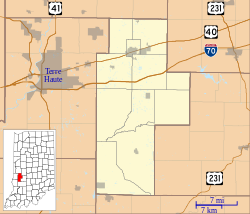
Howesville, Indiana
Howesville | |
|---|---|
| Koordinater: Koordinater : | |
| Land | Förenta staterna |
| stat | Indiana |
| Grevskap | Lera |
| Township | Lewis |
| Elevation | 548 fot (167 m) |
| postnummer | 47438 |
| FIPS-kod | 18-35014 |
| GNIS -funktions-ID | 436555 |
Howesville är en oinkorporerad gemenskap i Lewis Township , Clay County , Indiana . Det är en del av Terre Haute Metropolitan Statistical Area .
Historia
Howesville anlades 1856. Ett postkontor etablerades i Howesville 1858, och förblev i drift tills det lades ner 1909.
Geografi
Howesville ligger på .
- ^ "US Census website" . United States Census Bureau . Hämtad 2008-01-31 .
- ^ "Howesville, Indiana" . Informationssystem för geografiska namn . United States Geological Survey , USA:s inrikesdepartement . Hämtad 2009-10-17 .
- ^ Blanchard, Charles (1884). Counties of Clay och Owen, Indiana: Historiskt och biografiskt . FA Battey & Company. s. 332 .
- ^ "Clay County" . Jim Forte posthistoria . Hämtad 30 augusti 2014 .
