Saint-Christophe-en-Boucherie
Saint-Christophe-en-Boucherie | |
|---|---|
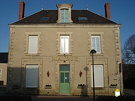
 Rådhuset i Saint-Christophe-en-Boucherie
| |
| Koordinater: Koordinater : | |
| Land | Frankrike |
| Område | Centre-Val de Loire |
| Avdelning | Indre |
| Arrondissement | La Châtre |
| Kanton | La Châtre |
| Regering | |
| • Borgmästare (2020–2026) | Jean-Luc Mançois |
| Område 1
|
26,89 km 2 (10,38 sq mi) |
| Befolkning
(januari 2019)
|
256 |
| • Densitet | 9,5/km 2 (25/sq mi) |
| Tidszon | UTC+01:00 ( CET ) |
| • Sommar ( sommartid ) | UTC+02:00 ( CEST ) |
| INSEE /Postnummer |
36186 /36400 |
| Elevation |
191–274 m (627–899 fot) (genomsnitt 268 m eller 879 fot) |
| 1 Franska fastighetsregisterdata, som exkluderar sjöar, dammar, glaciärer > 1 km 2 (0,386 sq mi eller 247 acres) och flodmynningar. | |
[sɛ̃ kʁistɔf ɑ̃ buʃʁi] Saint-Christophe-en-Boucherie ( franskt uttal: <a i=3>[ ) är en kommun i departementet Indre i centrala Frankrike .
Befolkning
|
|
Se även
Kategorier:


