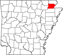
Nationellt register över historiska platser i Greene County, Arkansas
Detta är en lista över det nationella registret över historiska platser i Greene County, Arkansas .
är tänkt att vara en komplett lista över fastigheter och distrikt i National Register of Historic Places i Greene County, Arkansas , USA . Placeringen av folkregisterfastigheter och distrikt för vilka latitud- och longitudkoordinaterna finns med nedan, kan ses på en karta.
Det finns 18 fastigheter och stadsdelar registrerade i folkbokföringen i länet.
Denna National Park Service- lista är komplett genom NPS senaste listor som publicerades den 24 februari 2023.
Aktuella listor
| Namn i registret | Bild | Datum listat | Plats | Stad | Beskrivning | |
|---|---|---|---|---|---|---|
| 1 | Beisel-Mitchell House |
27 september 1996 ( #96001031 ) |
420 W. Court St. |
Paragould | ||
| 2 | Crowley's Ridge State Park-Bathhouse |
28 maj 1992 ( #92000537 ) |
Tillfartsvägen till det huvudsakliga servicecentret i Crowley's Ridge State Park |
Walcott | ||
| 3 | Crowley's Ridge State Park-Bridge |
28 maj 1992 ( #92000540 ) |
Tillfartsvägen till det huvudsakliga servicecentret i Crowley's Ridge State Park |
Walcott | ||
| 4 | Crowley's Ridge State Park-Comfort Station |
28 maj 1992 ( #92000538 ) |
Tillfartsväg till camping och stugområde i Crowley's Ridge State Park |
Walcott | ||
| 5 | Crowley's Ridge State Park-matsal |
28 maj 1992 ( #92000536 ) |
Tillfartsväg för arbetstagarebostäder i Crowley's Ridge State Park |
Walcott | ||
| 6 | George Rays Dragstrip |
21 februari 2006 ( #06000075 ) |
Highway 135 , 0,5 miles söder om US Route 412 |
Paragould | ||
| 7 | Greene County tingshus |
11 augusti 1976 ( #76000412 ) |
Court Sq. |
Paragould | ||
| 8 | Gulf Oil Company bensinstation |
16 augusti 1994 ( #94000850 ) |
Sydöstra hörnet av korsningen mellan Main och S. 3rd Sts. |
Paragould | ||
| 9 | Highfill-McClure House |
28 mars 2002 ( #02000260 ) |
701 W. Highland St. |
Paragould | ||
| 10 | Jackson-Herget House |
24 juli 1992 ( #92000907 ) |
206 S. 4th St. |
Paragould | ||
| 11 | Linwood mausoleum |
29 januari 2007 ( #06001314 ) |
Korsningen mellan W. Kingshighway och Linwood Dr. |
Paragould | ||
| 12 | National Bank of Commerce Building |
14 maj 1993 ( #93000423 ) |
200 S. Pruett St. |
Paragould | ||
| 13 | Gamla Bethel metodistkyrkan |
19 april 1978 ( #78000590 ) |
Väster om Paragould utanför Highway 141 |
Paragould | ||
| 14 | Paragould Downtown kommersiella historiska distrikt |
18 juli 2003 ( #03000646 ) |
Ungefär avgränsat av 3rd Ave., Kings Highway, 3½ St. och W. Highland St. |
Paragould | ||
| 15 | Paragould krigsminnesmärke |
20 juni 1997 ( #97000554 ) |
Korsningen mellan 3rd och Court Sts. |
Paragould | ||
| 16 | St. Marys katolska kyrka |
27 januari 2015 ( #14001198 ) |
301 W. Highland |
Paragould | ||
| 17 | Standard Oil Company Oil Station Garage Building |
16 september 2022 ( #100008154 ) |
202 West Vine St. |
Paragould | ||
| 18 | Texaco Station nr 1 |
20 juli 2001 ( #01000718 ) |
110 E. Main St. |
Paragould |
Tidigare listor
| Namn i registret | Bild | Datum listat | Datum borttaget | Plats | Stad | Beskrivning | |
|---|---|---|---|---|---|---|---|
| 1 | Big Slough Ditch Bridge |
9 juni 2000 (#00000629) |
24 september 2004 |
Länsväg 855 |
Brighton närhet | ||
| 2 | Eight Mile Creek Bridge |
6 april 1990 (#90000524) |
24 september 2004 |
AR 135 |
Paragould närhet | Byttes 2001. |


