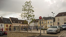
Authon-du-Perche
Authon-du-Perche | |
|---|---|
 Place du Marché i Authon-du-Perche
| |
| Koordinater: Koordinater : | |
| Land | Frankrike |
| Område | Centre-Val de Loire |
| Avdelning | Eure-et-Loir |
| Arrondissement | Nogent-le-Rotrou |
| Kanton | Brou |
| Intercommunality | CC Perche |
| Regering | |
| • Borgmästare (2020–2026) | Eric Girondeau |
| Område 1
|
34,82 km 2 (13,44 sq mi) |
| Befolkning
(januari 2019)
|
1 501 |
| • Densitet | 43/km 2 (110/sq mi) |
| Tidszon | UTC+01:00 ( CET ) |
| • Sommar ( sommartid ) | UTC+02:00 ( CEST ) |
| INSEE /Postnummer |
28018 /28330 |
| Elevation | 162–267 m (531–876 fot) |
| 1 Franska fastighetsregisterdata, som exkluderar sjöar, dammar, glaciärer > 1 km 2 (0,386 sq mi eller 247 acres) och flodmynningar. | |
[otɔ̃ dy pɛʁʃ] Authon-du-Perche ( franskt uttal: <a i=3>[ , bokstavligen Authon of the Perche ) är en kommun i departementet Eure-et-Loir i norra Frankrike . Den 1 januari 2019 slogs den tidigare kommunen Soizé samman till Authon-du-Perche. Källan till floden Braye ligger nära kommunen.
Befolkning
| År | Pop. | ±% |
|---|---|---|
| 1836 | 1 650 | — |
| 1881 | 1,427 | −13,5 % |
| 1901 | 1 439 | +0,8 % |
| 1921 | 1 157 | −19,6 % |
| 1946 | 1 186 | +2,5 % |
| 1954 | 1 107 | −6,7 % |
| 1962 | 1,166 | +5,3 % |
| 1968 | 1 220 | +4,6 % |
| 1975 | 1 396 | +14,4 % |
| 1982 | 1 319 | −5,5 % |
| 1990 | 1 270 | −3,7 % |
| 1999 | 1 287 | +1,3 % |
| 2008 | 1 285 | −0,2 % |
| 2015 | 1 227 | −4,5 % |
Se även


