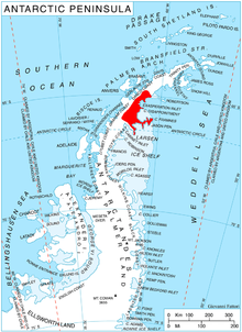
Adie Inlet
Adie Inlet ( Koordinater:) är ett isfyllt inlopp , 25 miles (40 km) långt i en nordväst-sydöstlig riktning, som ligger öster om Churchill Peninsula längs östkusten av Graham Land . Kartlagd av Falkland Islands Dependencies Survey (FIDS) och fotograferad från luften av Ronne Antarctic Research Expedition (RARE) under 1947. Namngiven av FIDS för RJ Adie, sydafrikansk geolog med FIDS, 1947–49.
Vidare läsning
- Tony Soper, en guide till vilda djur
- IL MILLAR, RJ PANKHURST & CM FANNING, Basement chronology of the Antarctic Peninsula: recurrent magmatism and anatexis in the Palaeozoic Gondwana Margin , Journal of the Geological Society, London, Vol. 159, 2002, s. 145–157
- Daniel McGrath, Konrad Steffen , Paul R. Holland, Ted Scambos, Harihar Rajaram, Waleed Abdalati, Eric Rignot, The structure and effect of suture zones in the Larsen C Ice Shelf, Antarctica, 12 februari 2014, https://doi.org /10.1002/2013JF002935
- RL Oliver, PR James, JB Jago, redaktörer Antarctic Earth Science , P 370
- International Symposium on Antarctic Earth, Geological Evolution of Antarctica , P 372
![]() Den här artikeln innehåller material som är allmän egendom från "Adie Inlet" . Informationssystem för geografiska namn . United States Geological Survey .
Den här artikeln innehåller material som är allmän egendom från "Adie Inlet" . Informationssystem för geografiska namn . United States Geological Survey .
